

Steavenson Falls
One of Victoria’s highest waterfalls
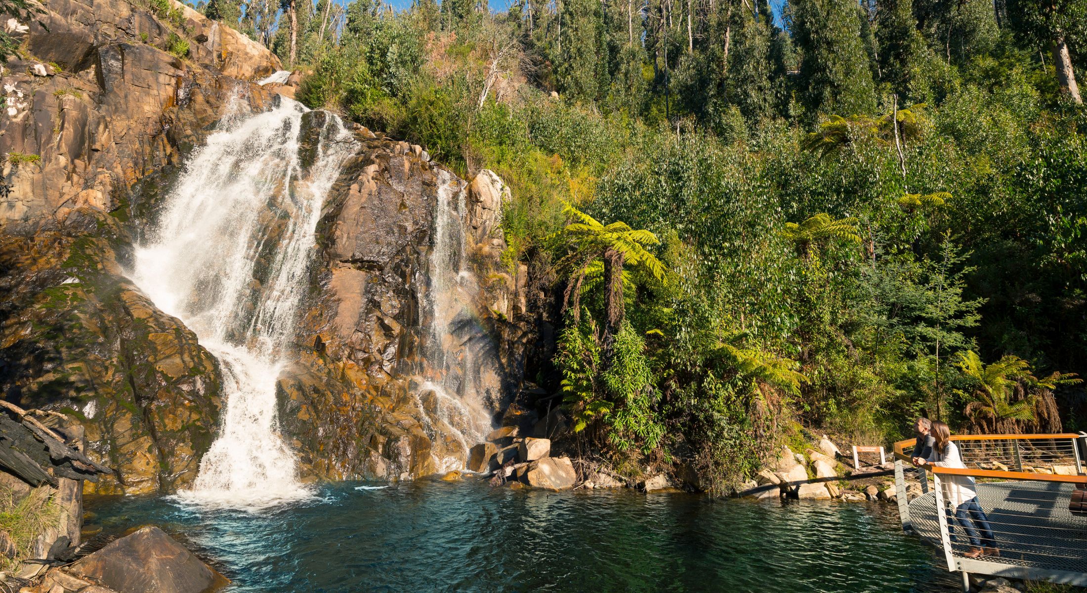
Steavenson Falls holds a special place within the Marysville community and sits protected inside a 190 hectare Natural Features and Scenic Reserve. Cascading 84 metres, it is one of the tallest waterfalls in Victoria and one of the region’s most photographed natural landmarks.
The Steavenson River begins high on the crest of the Great Dividing Range and flows year round through a forested catchment before plunging dramatically over the granite face. The result is a powerful and constantly changing spectacle shaped by season and rainfall.
An easy, flat walk of 350 metres from the car park leads to the main viewing platform. Suitable for all ages and fitness levels, the return walk of 700 metres typically takes between 15 and 30 minutes. The platform provides uninterrupted views of the falls and is a favourite for photography and quiet observation.
At night, the pathways and waterfall are floodlit between dusk and 11pm, offering a striking alternative perspective beneath the forest canopy.
Trails to explore
Beyond the main viewing platform, several trails connect into the wider Marysville network.
Top of Falls Lookout
One way 800 metres | 15 to 30 minutes
A formed but steep track leading to an elevated perspective above the cascade.
Keppel Lookout Trail
11 kilometres return | Approximately 5.2 kilometres one way | 1.5 to 2 hours
Part of the broader Marysville trail system, offering panoramic views across the Steavenson Valley.
Tree Fern Gully Trail
3.4 kilometres one way | 1 to 1.5 hours
A gentler riverside track suitable for walkers and cyclists, linking the Falls to the township.
The area also includes picnic facilities and interpretive signage sharing insights into the natural and cultural history of the region. Keep watch near the riverbanks, as platypus are occasionally sighted in the quieter sections of the waterway.
A landmark with local history
The falls and river were named in the early 1860s by John Steavenson, Victorian Assistant Commissioner of Roads and Bridges, who established a base in Marysville while overseeing road construction to the Woods Point goldfields. The town itself was named after his wife.
By the late nineteenth century, Steavenson Falls had become a well known tourist attraction, contributing to Marysville’s reputation as a mountain retreat destination.
Image credit: Visit Victoria

